
Top 10 Day Hikes from London
This article will give you my favourite ten hikes that are all well achievable in one day trip from London (warning: some of them might happily surprise you ; )
Who is this for?
This article is for anyone of all levels! There are hikes of ranging difficulties, all with levels from easy to difficult stated as well as the rough time it should take. Be sure to check the weather before going and hopefully you will have a great time!
What to bring
Approx. 1.5 - 2 litres of water (depending on the hike and temperature)
Waterproofs (check the weather, I would recommend always bringing a rain jacket, you never know what the British weather will bring!)
Snacks and energy bars
Maps (either GPS maps such as Alltrails or printed OS maps)

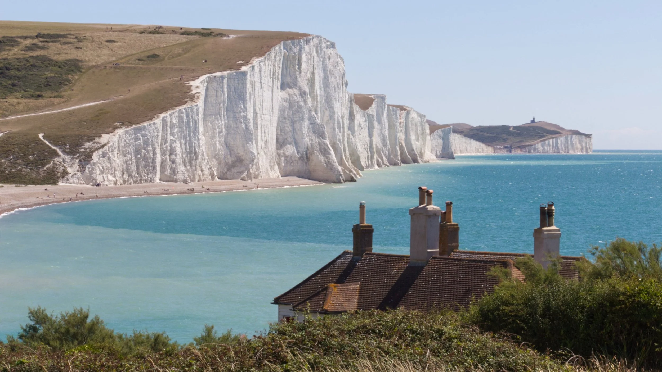
1. Seven Sisters Cliffs
Length - 21.7km (13.5 miles)
Elevation - 480m
Difficulty - Moderate
Hiking time - approx. 6 hours
How to get there by train
London Victoria to Seaford: 1.5hours
Eastbourne to London Victoria: 1.5 hours
Pubs and restaurants - see map below!
Highlight of the trail
The breathtaking view from the top of Beachy Head, the highest chalk sea cliff in Britain!
Weather and map linked below!

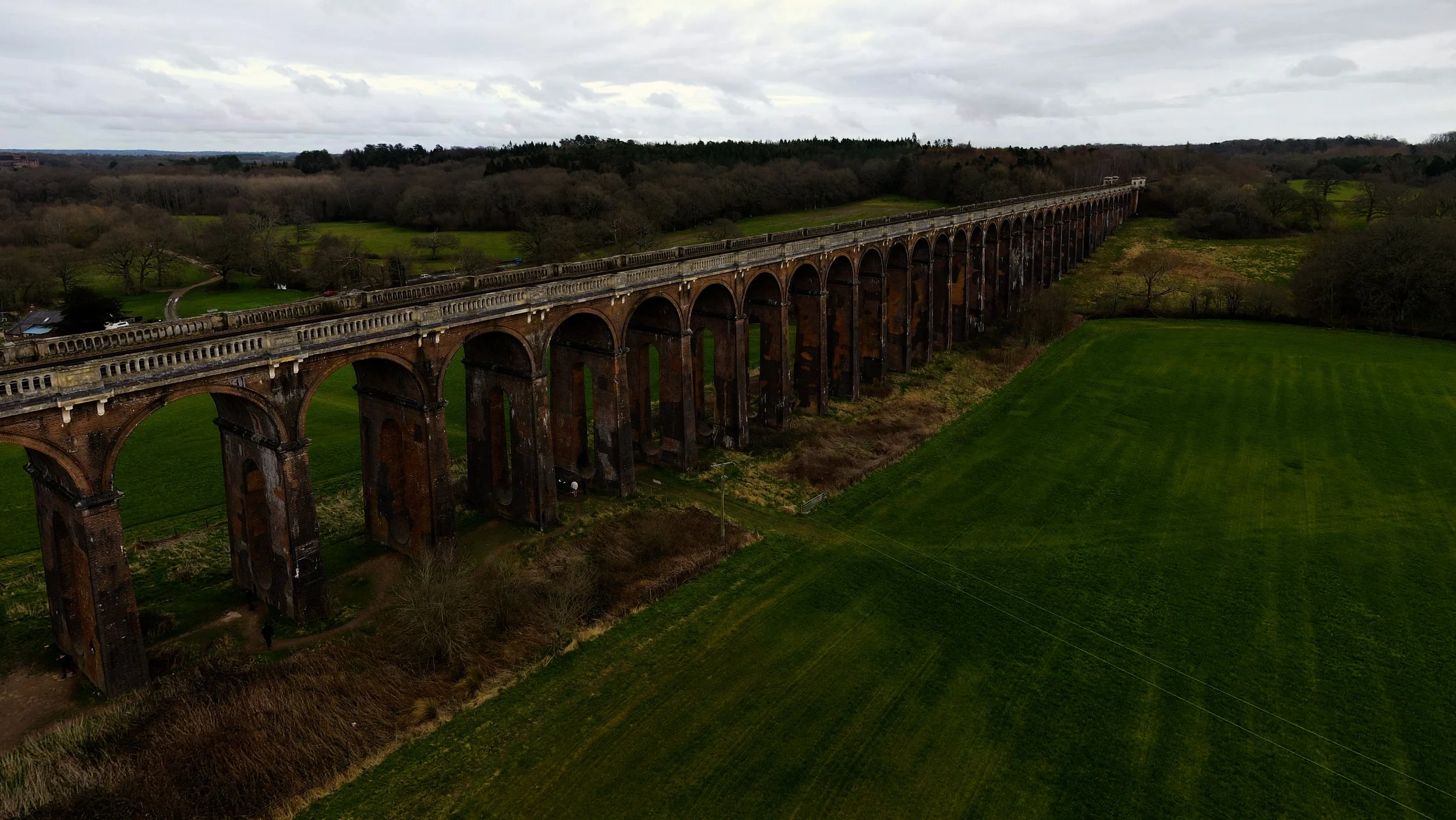
2. Ouse Valley Viaduct Circular
Length - 12.6km (7.8 miles)
Elevation - 380m
Difficulty - Moderate
Hiking time - approx. 3 hours
How to get there by train
London Bridge to Balcombe: 45 minutes
Pubs and restaurants - see map below!
Highlight of the trail
Taking photos within the vaiduct, a towering structure of brickwork, imposing itself in the surroundings.
Weather and map linked below!

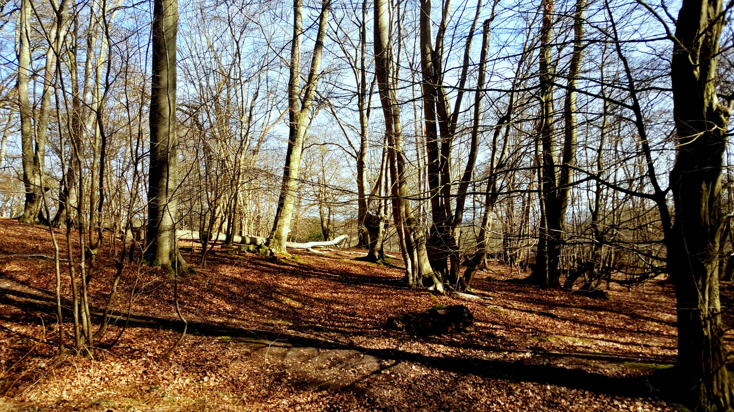
3. Oak Trail Walk, Epping Forest
Length - 11.1km (6.9 miles)
Elevation - 260m
Difficulty - Easy
Hiking time - approx. 3 hours
How to get there by tube (Central Line)
Liverpool Street to Theydon Bois: 35 mins
Pubs and restaurants - see map below!
Highlight of the trail
The enchanting ancient woodland of Epping Forest, where you can immerse yourself in the tranquility of towering oak trees and spot a diverse array of wildlife in their natural habitat.
Weather and map linked below!

4. Chess Valley Walk
Length - 17.7km (11 miles)
Elevation - 440m
Difficulty - Moderate (difficult when wet)
Hiking time - approx. 5 hours
How to get there by tube (Metropolitan Line)
Liverpool Street to Rickmansworth (1 hour)
Chesham to Liverpool street (1 hour 15 minutes)
Pubs and restaurants - see map below!
Highlight of the trail
The charming village of Chenies, where you can explore its historic Tudor manor house, Chenies Manor, and enjoy picturesque views of the surrounding countryside along the River Chess.
Weather and map linked below!


5. Box Hill Circular
Length - 11.9km (7.4 miles)
Elevation - 530m
Difficulty - Moderate
Hiking time - approx. 4 hours
How to get there by train
London Waterloo to Box Hill & Westhumble: 50 minutes
Pubs and restaurants - see map below!
Highlight of the trail
The panoramic view from the summit of Box Hill, where you can take in sweeping vistas of the Surrey Hills and the meandering River Mole below.
Weather and map linked below!


6. White Cliffs of Dover
Length - 9.7km (6 miles)
Elevation - 270m
Difficulty - Moderate
Hiking time - approx. 3 hours
How to get there by train
London Victoria to Dover: 2 hours 30 minutes + 45 minutes to trail start (oney way)
Pubs and restaurants - see map below!
Highlight of the trail
The stunning view from the top of the cliffs, where you can gaze out over the English Channel and, on clear days, see all the way to the coast of France.
Weather and map linked below!


7. North Downs Way, Canterbury to Shepherdswell
Length - 18km (11.2 miles)
Elevation - 340m
Difficulty - Easy to moderate
Hiking time - approx. 4 to 5 hours
How to get there by train
High speed one: London St. Pancras to Canterbury West: 1 hour
London Victoria to Canterbury East: 1 hour 30 mins
Pubs and restaurants - see map below!
Highlight of the trail
The serene and scenic stretch through the rolling Kent countryside, where you can enjoy picturesque views of lush fields, woodlands, and charming villages.
Weather and map linked below!


8. Leith Hill, Surrey
Length - 3.9km (2.4 miles)
Elevation - 160m
Difficulty - Easy
Hiking time - approx. 1 hour 15 mins
How to get there (its complicated)
3 hours 30 mins by train and bus
Pubs and restaurants - see map below!
Highlight of the trail
Reaching the summit, where you can climb the historic Leith Hill Tower and experience breathtaking panoramic views that stretch across the Surrey Hills and, on a clear day, all the way to London and the English Channel.
Weather and map linked below!


9. Thames Path, Marlow
Length - 11.1km (6.9 miles)
Elevation - 176m
Difficulty - Easy
Hiking time - approx. 2.5 hours
How to get there by train
Step 1. Farringdon to Maidenhead (Elizabeth Line): 45 mins
Step 2. Maidenhead to Bourne End (GWR): 15 mins
Pubs and restaurants - see map below!
Highlight of the trail
The picturesque stretch along the river, where you can enjoy the charming sight of Marlow's historic suspension bridge and the serene beauty of the waterway flanked by lush greenery and elegant riverside homes.
Weather and map linked below!


10. Little Marlow Walk, Chilterns
Length - 7.4km (4.6 miles)
Elevation - 160m
Difficulty - Easy
Hiking time - approx. 2 hours
How to get there by train
Step 1. Farringdon to Maidenhead (Elizabeth Line): 45 mins
Step 2. Maidenhead to Bourne End (GWR): 15 mins
Pubs and restaurants - see map below!
Highlight of the trail
The tranquil view of Spade Oak Lake, where you can enjoy the serene waters, abundant birdlife, and the peaceful rural landscape that surrounds this hidden gem.
Weather and map linked below!
