

Tour du Mont Blanc
A comprehensive guide.
The Key Facts
Walk length | 170km (105miles)
Elevation gain | 10,080m (33,070ft)
Difficulty | Difficult
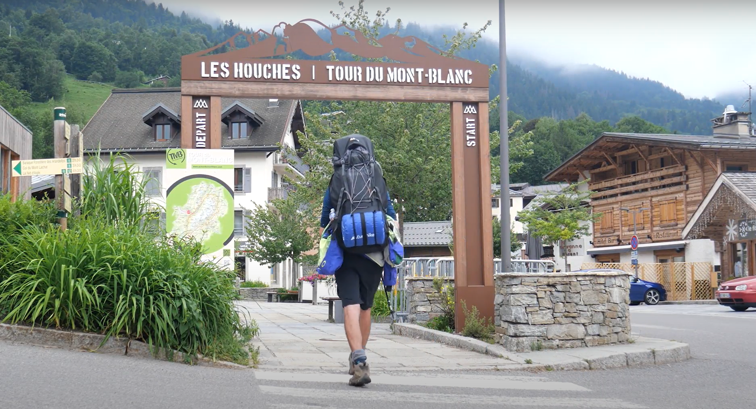
Start / End | Loop with Multiple options including (Les Houches, Courmayeur, Champex)
Recommended time to hike | End of June to early September
Busyness on trail | Very busy

Check out my adventure!


The Route
An Overview
170km, 10,000m elevation around one of the World’s greates mountains, embark on a journey through breathtaking landscapes and alpine vistas on the Tour du Mont Blanc. This iconic trek encircles the majestic Mont Blanc massif, leading adventurers through France, Italy, and Switzerland. With its rugged terrain, charming mountain refuges, and panoramic views, the Tour du Mont Blanc promises an unforgettable experience for hikers seeking both challenge and beauty. With each passing valley, one can experience new views, new cultures and new tastes.
I completed the Tour du Mont Blanc in July 2022. This was my first solo hike, an unforgettable experience. I learned heaps in just 9 days, I experienced clear blue skies as well as thunder and lightning. I saw rugged snow-capped mountain peaks as well as dense forests and imposing rivers. This tour simply had everything. I challenged myself more than ever before, but was it worth it? Without a doubt.
How difficult is the hike?
The Tour du Mont Blanc is a challenging hike not to be undertaken solo for beginers. The long distance and daily elevations of 1000m+ are not to be underestimated. However, the trail is very well maintained with little scrambling required, you will spend almost the entire walk on maintained footpaths, this greatly eases the walk.
Depending on your experience and fitness you may wish to complete the Tour du Mont Blanc in a variety of ways. These include:
Solo independent travel
Self-guided hiking tour
Guided hiking tour
Guided tours will spend the nights in refuges, easing the weight of your pack and will relieve you of route finding. In addition, it is popular for groups to book tours offering you to only walk the ‘best bits’ of the tour. See my section on ‘How to book the Tour du Mont Blanc’ for more.

Highlights of the Walk
These are my top three memories and locations from my journey along the Tour du Mont Blanc:
The approch to Refuge de la Balme
After a day and a half of miserable weather; rain, thunder, mist and clouds, I was feeling a little let down; having dreamt of the Tour for so long, being stuck in such bad weather was not what I had in mind. However, as I approached half way in day two, the valley approach of Refuge de la Balme, the clouds magically opened up revealing a majestic and imposing valley draped in low-hanging clouds. The scenerary burst with life all of a sudden, the cow’s bells could be heard, the snow capped mountains could be seen, the magic of the tour had finally arrived.
Aguillette des Posettes
Many groups don’t take the route from Col de Balme via the Aguillette des Possettes. What a shame! The Col represents the border between France and Switzerland and the first time you can see Chamonix and Mont Blanc for many days, a sign that the tour is nearly over. I had no expectations of more breathtaking views as they were already special at the Col. However, as I climbed over the rocky terrain, I saw the perfect view of Mont Blanc and took one of my favourite photos of it and myself.
The people of the trail
I didn’t know who and how many people I would meet prior to the tour. I was truly blown away by all the people my journey crossed paths with. People from all over the world were on the trail. Friendly, super talkative and full of stories of the mountains, my evenings were always full of enjoyment.


When to go?
There are a couple of things to keep in mind when deciding when to embark on the trail:
-
End of June to mid September.
This is the safest time to go. Often, outside of this time, snowfall may make the trail dangerous or unwalkable. I went in end of June and had one or two patches of snow to traverse. It’s slow going and not too pleasant, unless you’re an experienced hiker, I woulstay witin these dates.
The mountain conditions can always brng surprises, it is not unknown to see snowfall throughout the summer too, so check daily the weather forecast to plan your next day. See my section called ‘Weather’ for more.
Late June also has the advantage that the mointain flowers will be at their most colourful!
-
The summer holidays in France typically fall between July 15th and end of August.
Expect the trail to be busiest then. There will be a higher demand for refuges. If you’re planning to hike during this time, book your refuges as early as possible!
During my hike in the end of June, the trail was stil busy, especially in the most famous parts, but I also got my fair share of peaceful hiking.
Be sure to leave early (before 8:30am) if you want to avoid the groups.
-
Taking place at the end of June, this will draw large crowds to Chamonix. The route stays between Chamonix and Col des oosettes.
I was in Chamonix on the very day in 2022 and loved it! The atmosphere was electric, I was surrounded by hundreds of top runners, all with the same passion of pushing themselves to the limit.
Expect to find a couple thousand runners along the trail if you hike in the last days of August. There is a fairly small impact of the hiker, but make sure to book accomodation in advance.
Suggested itineraries
Below is a list of suggested itineraries from seven to eleven days. Below, you can also find a short description of the route between each stage (11 stages total) and a couple useful tips for each stage.
Les Houches to Les Contamines
Distance: 17.5km (10.9miles)
Elevation gain / loss: 1010m / 850m
Stage 1 will plunge you straight into an uphill as you hike from Les Houches to Col de Voza. The first stage involves a bunch of road-walking and is generally more straightforward than later stages, however it will be a good warm up and introduction to what the tour has to offer. The first uphill may seem daunting and never ending but after 6km, you will have already completed the hard work of the day.
I stayed at Camping Le Pontet, just after Les Contamines. The campsite was full of other TMB hikers which was a great place to meet. We were served hot food with drinks available. The campsite hosts a small shop with small amenities like bread, snacks and TMB merchandise.
On a bad day, this route is recommended over the alternative route.

2. Les Contamines to Les Chapieux
Distance: 19km (11.8miles)
Elevation gain / loss: 1360m / 970m
This stage goes to the head of Val Montjoie and crosses over into the Vallee des Glaciers by way of Col du Bonhomme and Col de la Croix du Bonhomme. The stage was certainly challenging with a 1300m+ elevation gain. You will pass the Notre-Dame de la Gorge, powerful waterfalls, serene valleys and more. The views on a nice day are really incredible although my legs really felt the strain upon arriving into Les Chapieux.
I camped outside the tourist office of Les Chapieux. There is a small shop in the village and you can eat dinner at the refuge L’edpicerie des Chapieux even if you’re not staying there. The camping was free with some facilities including sinks and toilets. I managed to charge my phone in the tourist office before it closed.
3. Les Chapieux to Rifugio Elisabetta
Distance: 14km (8.7miles)
Elevation gain / loss: 1100m / 460m
On this stage you will leave France and enter Italy. The stage is slightly easier than stage 2 with a 1000m climb to reach but the trail is well maintained and generally zig-zags all the way up to Col de la Seigne. At the Col, you will be treated to stunning panoramic views all around you. Leaving the Col is a hotspot to take the wrong path. Be careful when heading down to Rifugio Elisabetta to not end up on the wrong side of the valley.
I completed this stage before 1pm and carried on to Courmayeur on the same day.


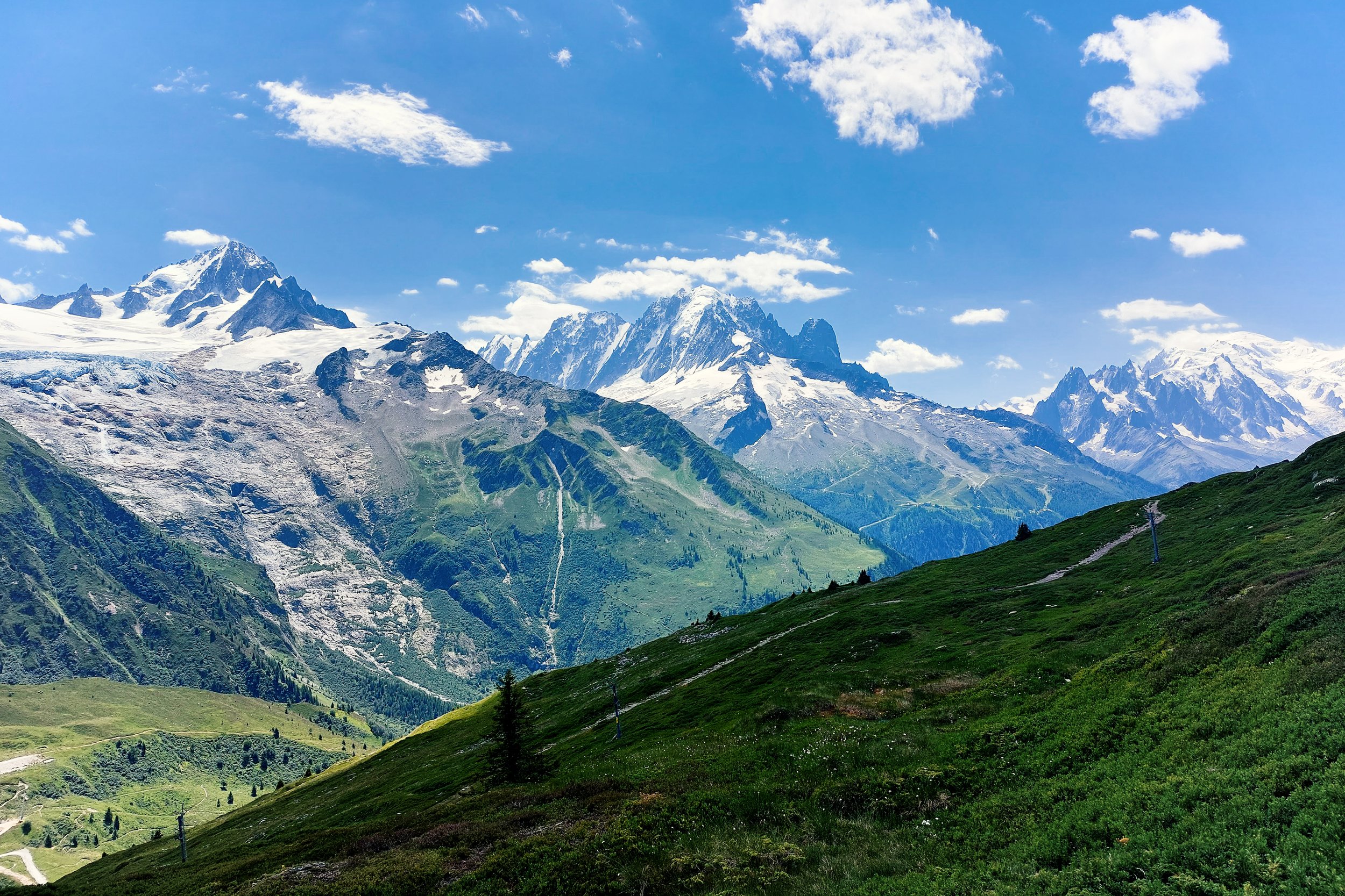
4. Rifugio Elisabetta to Courmayeur
Distance: 15.5km (9.6miles)
Elevation gain / loss: 580m / 1550m
After several stages of 1000m+ elevation gain, stage 4 is a relatively modest elevation gain. The stage is more varied following the high peaks around Col de la Seigne. You will enter forested areas with large streams curving their way into the landscape. Depending where you plan to sleep, you can either take a left or right turn just before Cabane du Combal. Left takes you down the valley to various campsites including Camping La Sorgente where I stayed. Many hikers take a bus from La Visaille to their campsites or Courmayeur as the walking here turns into road walking. The main route however turns right and goes uphill and leads you directly to Courmayeur.
Courmayeur is a great place to resupply. There is a pharmacy, supermarkets, ATMs and plenty of restaurants. This will be the last major town of Italy, so can be a useful place to stop of at.
I stayed at Camping La Sorgente. It was a beautiful camping spot, however there weren’t many other TMB hikers here, it was more for campervans and larger camping. If you take this route, I would highly recommend taking a bus to courmayeur. The road is winding without a pavement and can be somewhat dangerous to walk on.

5. Courmayeur to Rifugio Bonatti
Distance: 12km (7.5miles)
Elevation gain / loss: 1080m / 280m
In good weather conditions, this stage promises to be one of the highlights in the TMB. Following the steep uphil throgh dense trees to Rifugio Bertone, the path becomes more genlte and undulating whilst you are treated by stunning views of Mont de la Saxe and Val Ferret.
Rifugio Bonatti is also regarded as one of the premier refuges on the trail. Offering stunning panoramic views, the refuge is well worth a stay. You should book well in advance as the limited space is often booked very quickly. Click the link here to book at Bonatti. Bonatti accepts only cash however, so make sure to be carrying 60 euros at least for accomodation and dinner.


6. Rifugio Bonatti to La Fouly
Distance: 20km (12.4miles)
Elevation gain / loss: 980m / 1400m
Crossing the Grand Col Ferret takes the trail out of Italy and into Switzerland and along the eastern edge of the Mont Blanc Massif. Another great route, when you reach the Col, you can look back along the whole Italian section that you have just walked! Following the Col Ferret, the trail takes you downhill in a gentle descen to La Fouly. The stage is moderate difficulty and turns into a pleasant walk in the last couple of kilometres to La Fouly.


7. La Fouly to Champex Lac
Distance: 15.5km (9.6miles)
Elevation gain / loss: 510m / 650m
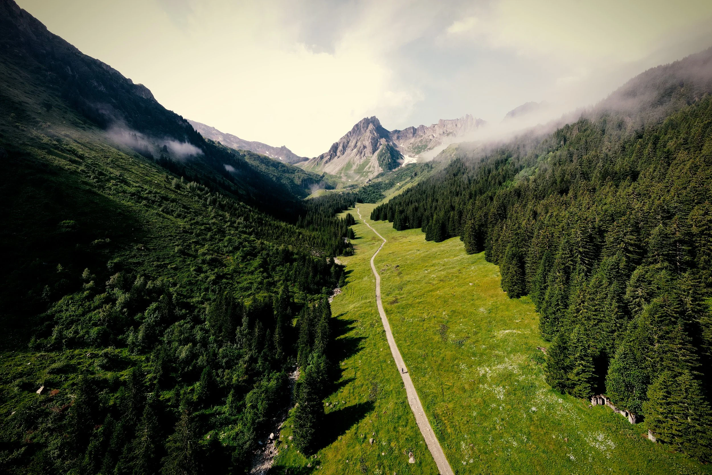
This is the easiest stage of the TMB and is often skipped as a bus is available from La Fouly to Champex Lac. The section is a valley walk throughout. Here, you will experience the peaceful and calm nature of a Swiss valley, where the way of life of local communities appears not to have been affected by modern technology.
8. Champex Lac to Trient
Distance: 16km (9.9miles)
Elevation gain / loss: 850m / 1040m
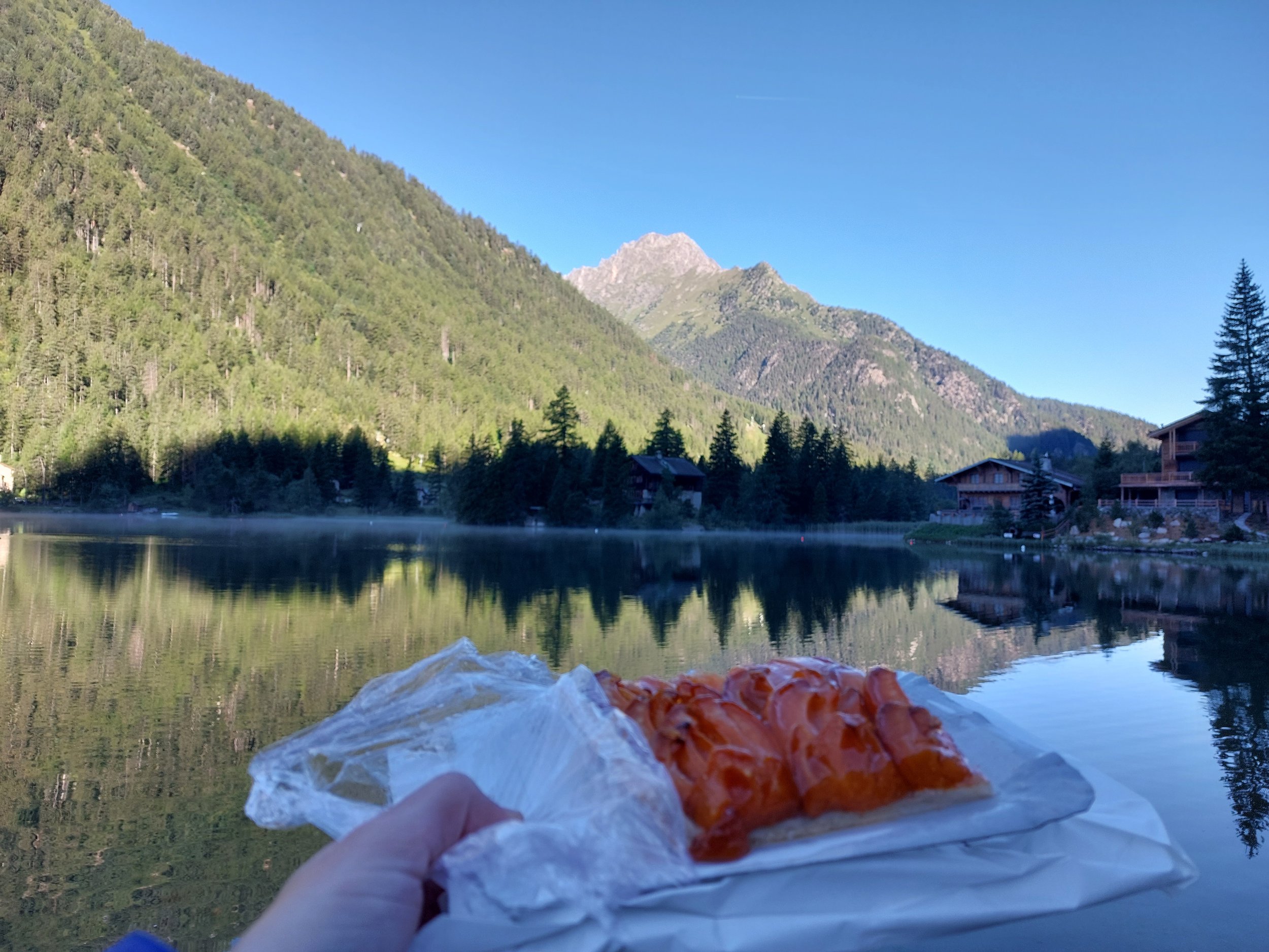
I would highly recommend getting out beside the lake Champex in the early morning as the water is perfectly still providing a stunning reflection. I bought a sweet pastry and ate it by the lake before my days hike. The hike itself will loop you around the northern tip of the Mont Blanc massif. You will pass meadows, patches of forest, rough combes and high alpine pastures along the way. Alp Bovine is a good stopping point for lunch, offering stunning views into the depths of Switzerland before you descent into Trient.
There are several hotels and a refuge (Refuge La Peuty) to choose from. Camping is free; you are allowed to pitch your tent on the field next to La Peuty. Once again, the camping facilities are limited, although the refuge offers good food and drinks (as well as an option to buy lunch for the following day).


9. Trient to Tre-le-Champ
Distance: 14km (8.7miles)
Elevation gain / loss: 980m / 840m
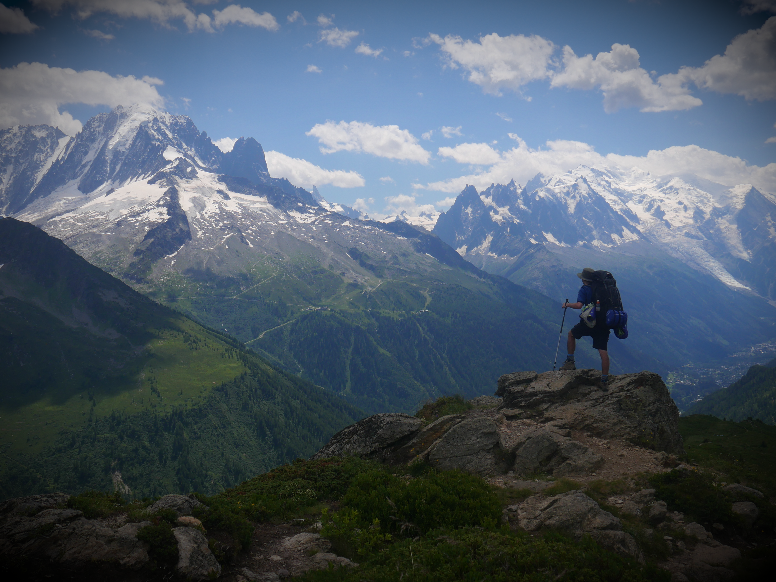
The climb up from Trient to Col de Balme is done at a relatively friendly incline and was one of my easier climbs. Reaching the Col, you will be treated to spectacular views into Chamonix and Mont Blanc, signifying that you are on the last stretch of the tour. The Col also marks the border between Switzerland and France. Following this, the route takes you along the Aguillette des Possettes, personally one of my highlights of the tour. The views of Mont Blanc on a nice day are incredible, you really feel like you are on top of the world. Many guided groups and hikers skip this stage but I would insist on doing it!
The descent into Tre-le-Champ is faily steep but not unmanagable. Accomodation is available at Auberge la Boerne. They allow camping as well for a small fee, but due to the small field size, only apporoximately 10 - 15 tents will fit, so do not arrive at 8pm expecting to find a spot!

10. Tre-le-Champ to La Flegere
Distance: 8km (5miles)
Elevation gain / loss: 730m / 270m
The final two stages offer incredible alpine paths as you ascend again up to Tete aux Vents. The stage involves climbing a series of ladders, rungs, platforms and timber steps. Some hikers may find these troublesome, especially those with vertigo. Another route (also a must-do on a beautiful day) takes you to the famed Lac Blanc, 250m above Tete aux Vents. Camping is available in La Flegere next to the hotel.


11. La Flegere to Les Houches
Distance: 18.5km (11.5miles)
Elevation gain / loss: 900m / 1770m
The final stage of the tour offers remarkable views of your alpine surroundings. The final descent is steep and feels never ending. It is a tough ending to the tour, but one that will make you feel even prouder once you reach the archway at Les Houches.

Clockwise or Anticlockwise?
The route is tpyically done anti-clockwise, however both options have their ups and downs. The elevation of either route is similar and will not impact which route you choose.
Anticlockwise
For:
The standard route done by most hikers, it can be comforting to be surrounded by more hikers, especially if an inexperienced hiker.
You finish the hike passing above Chamonix with Mont Blanc in view - a great way to end!
Easier to walk with other hikers you meet along the way as they will also likely be going anticlockwise.
Against:
You will likely be walking with many groups, especially during the school holidays. This may make the trail congested and unpleasant if you’re looking for a peaceful experience.
Clockwise
For:
You will be hiking against the flow of traffic, meaning you will not be ‘stuck’ between large groups.
Each day you can meet new hikers as most will be hiking anticlockwise.
You will pass hikers going in the opposite direction, they can inform you on the trail condition or anything else to watch out for.
Against:
The start from Les Houches takes you imediately on a 1500m elevation ascent. An alternative starting point may be preferred if you dont want to be thrown immediately into such a climb!
Guided vs Self-guided
One of the first decisions you will be making is whether to get a guide or go self-guided. This chapter will present the pros and cons of both options, give you recommendations of which to choose and suggest companies that offer great guides to make your trip as memorable and enjoyable as possible.
Independent Hiking
Pros
It’s actually quite easy! The trail is extremely well marked (see my section of maps and waymarking). There are plenty of online and offline maps to guide you along the way.
You are most flexible when hiking without a guide. You can go at your own pace, not the pace of a group; you can stop and enjoy a moment at will; you can adapt your hike as best suits you.
Meeting people - you will meet other independent hikers along the way, so do not worry about being alone!
More peaceful - I personally go to the mountains for the beauty of stillness, not to be around many people every day.
Cons
Requires more planning - you guessed it, doing the trail yourself required you to become familiar with all aspects of the trail including the weather conditions, trail conditions, refuges, camping, water locations etc.
Less aware - guides will explain to you so much about the trail, its history and much more
Unadvisable for inexperienced hikers - planning such a large trip can be daunting and potentially dangerous if you have never been on a multi-day hike before. Taking a guide will allow you to gain experience and learn tricks of the trail. See my blog for more!
Guided Hiking
Guided tours come in many different forms. Some of the main types include:
The classic full tour
TMB ‘express’ - complete a shortened version seeing many of the highlights
TMB half (East or West)
Pros
Hastle-free - the planning, booking is all done for you, all you need to do is hike!
Many options - there are many forms of guided hiking, from 1-on-1 guides providing you the most personalised and private tour; group hikes hiking the full tour; group hikes doing only the ‘highlights’ of the trail and more. Do some research and think about which one suits your needs the most.
Meeting fellow hikers - many groups are a mixture of people meaning its a great way to meet others with similar interests and hobbies.
Cons
More expensive - depending on many factors such as trip length, luggage transfers… the price may vary, but expect to pay a LOT more than through independent hiking.
Different paces - i have seen groups on my trip where one person was by the far the slowest. This definitely wasn’t the best experience for him, having to be always catching up. Be sure to book a group for you, not a group that will definitely exceed your ability.
Less flexibility - you will spend your hike with the same people from start to finish. Whilst this may be great, I personally love the freedom of meeting new people, camping with my tent and also having some alone time to be with nature and nature alone.
Guided tour companies

Weather
The weather in the Alps can be notoriously unpredictable due to the region's complex topography and diverse microclimates. Rapid changes in elevation and the interaction of air masses from different directions contribute to this variability. As warm, moist air rises over the mountains, it can cool rapidly, leading to sudden cloud formation, rain, or even snow, making it challenging to forecast with precision.
Top tip: Never trust the weather forecast more then 24 hours in advance! The weather changes very rapidly, you must be prepared for all weather conditions during your adventure. The day before I started, my weather forecast was predicting 5 days of thunderstorms! Thankfully, that wasn’t the case at all as the weather changed so rapidly for the better :)
Waterproofs (including boots) are essential as well as sun cream, and a cap to protect you from the sun. In general, you won’t need crampons if hiking during the summer months. Winter conditions can be highly unpredictable and only go during the winter if you’re an experienced hiker.
Weather Forecasts
Food - the jewel of the Tour!
What else can I say other than, the tour is for you if you want to indulge in the delicious food of France, Italy and Switzerland.
Important: CASH - make sure to bring enough cash (euros in France and Italy, Swiss Francs in Switzerland) as card payments can not be relied upon.
Supermarkets
You’ll be able to find supermarkets in the larger towns of the trail including: Chamonix, Les Houces, Les Contamines, Courmayeur, La Fouly, Champex and Argentière. There are enough supermarkets to supply yourself for 2 - 3 day intervals easily. You will be able to find a good selection of cheese, meats, sausages, pasta (especially in italy!) etc. the essentials for a hiking trip. In addition, you will be able to buy medical products such as Paracetamol or blister plasters.
Caution for Sundays and holidays - supermarkets may be closed, so plan in advance!
Refuges
Food is offered in all refuges along the tour. Typically, the food options can be pasta, lasgne, meats and cheeses. Be sure to check in advance for dietary requirements as the options may be limited in this case. Expect for the food to not be too cheap! Often, supplies have to be delivered via helicopter.
Most refuges will offer breakfast and a packed lunch for an extra fee. This can speed up your morning prep and help you get away nice and quicky. You can ask for this on the day of your stay.
My highlights:
Pasta at Rifugio Elisabetta
Having just crossed into Italy for the first time, Rifugio Elisabetta awaits you; what better place to stop for lunch for some pasta!
Burger and cocktail at Refuge La Peuty
They really do taste even better after a long, hot days walking! Great social space too.
Morning pastry at Lac Champex
Water
There are many opportunities to get water along the trail. A great source is through meltwater streams flowing into the valleys. There are many many sources along the trail. Meltwater is particularly cold and extra refreshing! A water filter is useful here to make sure the water is safe to drink. Take caution of drinking water close to areas of farmland as there may be an increase in contamination here from the animals. The added bonus of using meltwater streams is you won’t need to carry as much water throughout the day. Make sure to plan the day taking into account the length of walking between streams if you choose this path.
Otherwise, water can be readily found in refuges, mountain huts etc. See my map of the route above for the locations of accomodation. Water can also be found from taps along the way. You can recognise them with troughs to collect water from the tap.
Camping
If you wish to cook your own food along the trail, here are some points to consider:
Gas canisters can be bought in the main towns of Chamonix, Les Houces, Les Contamines, Courmayeur, La Fouly and Champex. Make sure to buy a canister a) with the correct attachment for your stove system b) a large enough size for how much cooking you are planning.
Use the supermarkets! Save weight in your backpack and re-stock in the towns along the trail. This will make your pack weight significantly better.
At campsites, you will able to buy dinner and small snacks.


Accomodation
Accomodation on route is plentiful, check out my map above for a list of all refuges and campsites. There are a couple of things to bear in mind before going on the trip.
-
Camping is a popular option along the trail and a great way to meet other hikers as you will likely be seeing familiar faces at each campsite.
Desginated campsites will cost approximately 10 - 20 euros whilst in several stages, you can camp for free by refuges. This includes at Les Chapieux, Trient and La Flegere.
Campsites do not need to be booked - there will be space for hikers which really helps your planning.
Wild camping:
Wildcamping is forbidden in France, Italy and Switzerland. You may face a fine if spotted.
-
There are many refuges along the Tour. Some of the most spectacular are:
Refuge Lac Blanc
Cabane Combal
Rifugio Bonatti
Refuge des Mottets
Refuge Col de Balme
You must book your space early. Space is limited and is taken very quickly. Booking several months in advance is advised.
Sleeping liner:
You must take a sleeping bag liner when staying in refuges (or pay extra for a sheet). Liners are small in size so will not impact your backpack but provide good comfort and warmth. I use the Sea to Summit Thermolite Liner.
-
Camping
Pros:
A lot cheaper than refuges.
More flexible, you won't need to book campsites in advance.
More comfortable (providing you have a waterproof tent), sleeping alone in your own space is often nicer than being packed with strangers in a refuge.
Cons:
Heavier backpack - carrying your sleep system will include a tent, a sleeping bag, sleeping pad and potentially a cooking system. That's a lot of extra items to carry!
Weather - bad weather can severly dampen your mood when camping.
Limited campsites - some areas of the tour are limited in campsites (see my map above for more)
Refuges / hotels
Pros:
Hotels can be a great way of relaxing and winding down after a long day on trail.
Weather resistant - rainign outside? thunder? lightning? You're ok and sleeping comfortably.
Dinner and lunch for the next day - for a little extra cost, dinner and lunch will be prepared for you.
Cons:
More expensive. It's not easy transporting food and goods to many of the refuge locations, and the prices will reflect this!
Sleeping with many people in one room - you may be stuck with other people waking up in the early hours, snoring or talking loudly when trying to sleep.
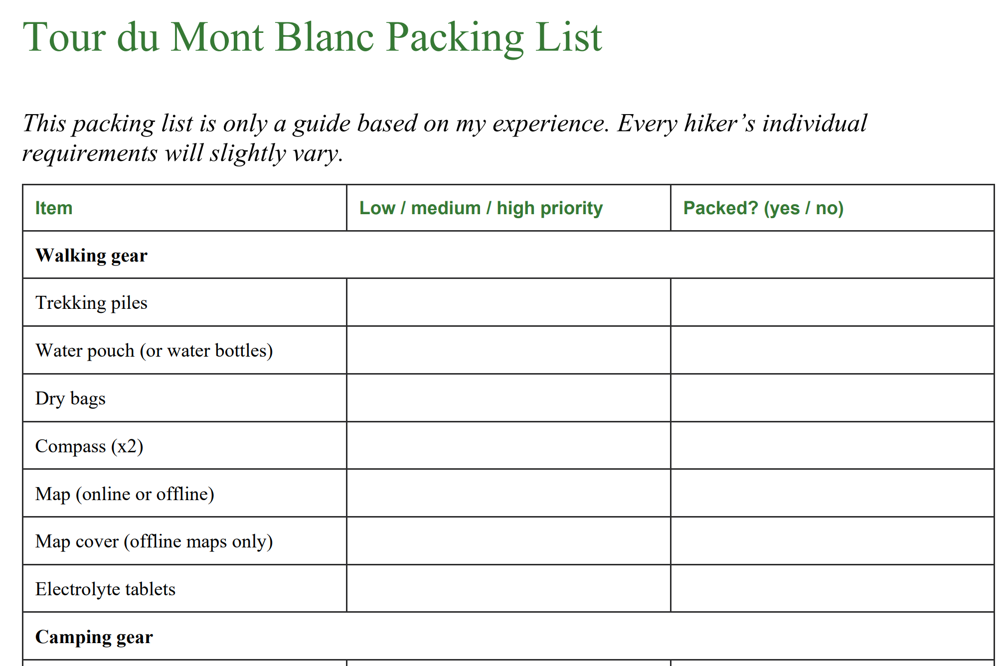
Packing advice
The tour is full of ascents and descents making a light backpack crucial when completing the hike. Listed below are some of the essentials for the Tour du Mont Blanc.
Trekking poles - really useful when ascending and descending. They spread your load away from your legs and also protect your knees when descending.
Rainjacket and trousers - the mountainous weather should not be underestimated. These two items are essential.
Hiking boots and socks - highlighly important for the health of your feet. Your boots should provide ankle support and also be waterproof. This will reduce the risk of injury and blisters. Your boots should be worn in - do not buy new boots and not try them before your hike.
Sleeping bag liner - most refuges will require you to bring a liner to keep their bedsheets clean (imagine every day new smelly hikers sleeping in the same day!)
Download my Packing List PDF for all my recomendations!
Suggested packing list

Languages
‘Mont Blanc has one tongue’ is the famous saying. French is the preferred language along the French and Swiss sections; Italian is preferred in Italy. Don’t expect English to be understood in all the villages and refuges you pass through. In my experience, a little bit of French and Italian certainly helps along the way! Here are some common phrases in both languages:
English - French - Italian
Hello - Bonjour - Ciao
What’s your name? - Comment t'appelles-tu? - Come ti chiami?
North East South West - Nord Est Sud Ouest - Nord Est Sud Ovest
Footpath - Sentier - Sentiero
Refuge - Refuge - Rifugio
Do you speak English - Parles-vous anglais? - Lei parla inglese?
Food - Nourriture - Cibo
Water - Eau - Acqua
Beer - Bière - Birra
Cash or Card?
Answer: Cash (France & Italy); Card / Cash (Switzerland)
France & Italy: Euros
Switzerland: Swiss Francs
Whilst the ability to use a card is becoming easier and easier, many refuges will not acceept cards still. Bring more cash than you expect. Having cash will be relieve stress if ever cought in a unexpected situation (needing a taxi, food, accomodation etc.). This has happened to me before, I can not overstress the importance of cash!
Having said this, Switzerland is very card friendly, shops and even the bus at stage 7 (Ferret or La Fouly to Champex Lac) will accept cards. Shops will also accept Euros banknotes (not coins) and return you Swiss Francs. To conclude the Swiss section, you can get away with carrying very little to no Swiss Francs on the trail!
There are opportunities to withdraw cash in the followings areas:

Which refuges only accept cash?
Refuge Plan Glacier
Refuge Miage
Auberge du Tuc
Refuge Nant Borrant
Refuge de la Croix du Bonhomme
Auberge de la Nova
Refuge Mottets
Refugio Bertone
Refugio Bonatti
Refuge Les Grans
Refuge Bellachat
Top tip: always pay in the local currency when paying by card
Transportation
Flying there - nearest airport
Geneva is the closest airport to the Mont Blanc massif. Flights are readily available through EasyJet from many parts of Europe. Check out flight availability below via Skyscanner. Multiple transfer companies are operating from the airport to take you to Chamonix (Les Houches) or Courmayeur.
Operating companies:
After taking an EasyJet flight, why not carry on with EasyBus! I took this company, they were cheap and arrived on time and were friendly during the trip.
A lowcost operator in Europe, FlixBus offers a lowcost bus service to Chamonix.
Bus options are available but also the cheapest option is to hop in and carpool! Depending on availability, blablacar offers you to jump in a registered persons car. This can be a social, lowcost and fast alternative.
Arriving to Les Houches from Chamonix
Bus no. 1 and no. 8 will take you between Chamonix and Les Houches in approximately 15 minutes. The bus was free when I went in 2022, but bring some cash just in case!
Chamonix to Courmayeur
Buses are available between Chamonix and Courmayer. There are typically four buses per day. Each bus will cost you approximately €15. Find out timetables and more more here.
Local bus routes
If you want to shorten your route or have hit bad weather, there is a good network of buses where road access is good. This revolves around the towns of Les Houches, Les Contamines, Courmayeur, La Fouly, Champex and Argentière. The buses are well priced and run frequently in the summer months. A quick google search for your specific route will give you a quick answer!
Cable cars
There are a couple of cable cars along the route that can help you avoid the gruelling uphills or get down the valley in case of bad weather. Follow the links to find out more inlcuding prices, timetables, and more.
Phone and Internet
Wifi
Hotels will likely have wifi, but do not expect most refuges to offer the service, espcially in remote locations. Larger towns like Courmayeur and Chamonix will offer more wifi. Some places like Les Chapieux offer (slow) internet at a very expensive price.
Mobile data
Check your phone provider for more information. By searching e.g ‘Vodafone Coverage Map’, you will be able to find out with regards to your provider. Typically, phone signal is good but likely you will not have a coverage entirely during the trail. Check your map for valleys coming up (liek Les Chapieux), they are the most likely areas for signal to be lost.
Charging
The standard EU two pin plugs are used in all three countries. You will need an adapter if coming from overseas. Most restaurants / accomodation that I stopped in offered charging, it is readily available along the trail. Consider bringing a portable charger for multiple devices / if camping.
Important tip: often in refuges, everyone wants to use the limited power sockets. So many plugs in a tight space may make the space congested. Often, bulky, large adapters may not fit into a socket. Consider buying a EU charger outright or bringing a power bank to overcome this problem.

Maps and Waymarking
Maps come in two forms: digital or printed. Personally, I like the feel of a printed map as well as knowing its battery won’t die on you. Digital maps have advantages including often a GPS tracker, live weather forecasts and general ease of use and small size compared to a map. However, phones are dependent on battery life, sometimes internet signal and the performance of your phone can vary on a cold night or with heavy rain it may be difficult to use the touchscreen.
Maps require more planning. I like to draw the route out with a sharpie. Maps are often bulkier and the often cost between £10 - £20 each. However, self-navigating can be a rewarding and fun process on the trail. Don’t forget a compass too whe using a printed map.
Online Maps:
Printed Maps:
Cicerone guide book map (click here)
IGN (Institut National de l'Information Géographique) 1:25,000 maps
Rando Editions - 1:50,000 single sheet map
Waymarking
The route has three didfferent markings, depending on the country you are in, see below. In general, the waymarking is very good and clear. I found the Italian section to be slightly less marked than the French and Swiss sections, although in all three countries, the trail was nearly always clear.

France: red and white stripes
(source: Trekking Mont Blanc)

Italy: yellow TMB sign

Switzerland: yellow signposts with red and white stripe
Luggage Transfer
The Tour du Mont Blanc is one of the most popular long distance hiking trails in the world, therefore a large industry has grown around it, one being luggage transfer. Being able to carry only a day pack with water, food and rainjacket will make a massive difference along the trail, I can not understate this enough!
Pros
Only carry a day pack - great for the tough uphills, especially if you are a less confident hiker.
Reduced stress - less chance of items breaking, getting wet etc
Quicker hiking - with a smaller backpack, you will be able to eat up the kilometres much quicker than with a large backpack. This will save you time and money by sleeping in less refuges.
Cons
Extra cost - depending on the number of hikers you are with, expect to pay in the region of 150 euros per person.
Reduced flexibility - you become tied into the schedule of your bags.
Not all refuges accept luggage tranfers due to the terrain and location - this includes Refugio Bonatti, Rifugio Elisabetta, Rifugio Elena, Refuge Croix du Bonhomme, Cabane Combal and Refuge Lac Blanc.
Recommended Companies
Key Contacts and Emergencies
Dial 112 for ALL general emergencies.
Mountain rescue:
France | 112
Italy | 118
Switzerland | 144
Make sure you have adequate insurance cover. Many insurers specify the maximum elevation they will cover you to. Make sure you are ensured to all elevations on your hike. The maximum elevation of the TMB is approximately 2600m. It is advisable to leave a copy of your insurance with a member of family or friend, and take the original with you. EU citizens are eligible to reduced cost (sometimes free) urgent medical treatment through the European Union Health Insurance Card (EHIC) in all three countries. However, payment may be required at the time of treatment, so be adequately insured.

Further References
There are some great ways to get further information regarding the hike! These three resources are where I find out most about any hike, not just the Tour du Mont Blanc.

-
One of my most underrated souces of information, there is a facebook group for any hike out there. In the case of such a popular walk, there are many groups with thousands of members each.
Ask any question, read other questions, other posts, a faebook group is just a trasure trove of informtion. I can guarantee any question will get answered.
In addition, checking groups on the day of hiking can give important updates on the trail condition or anything ese to be aware of.
-
To get a real sense of the feeling of a trail, there is no better site. YouTube offers a unique insight where words on a page simply are not enough. When watching a video, try and look out for things like busyness on trail, the path condition at the time of year and small details like sources of water, streams etc.
Most youtubers (below 10,000) subscribers will answer questions you may well have as well, I certainly do!
Finally, plug for my own video… I’ve tried to express my thoughts and feelings during the video as well as sharing some stunning scenary, so check it out!
-
My go to guides are always Cicerone.
For £10 - £20, the level of detail is second to none. Detailed descriptions of each stage, many key facts, a 1:25,000 map, the guide is well well worth it.
You will be able to learn abut the local area’s deep history as well as the geology of the area through this guide.
YouTube is a great source of information, not just my video! ; )