

West Highland Way
A comprehensive guide.
The Key Facts
Walk length | 155km (96.5 miles)
Elevation gain | 4,038m (13,240ft)
Difficulty | Moderate
Start / End | Milngavie / Fort William
Recommended time to hike | April to October
Busyness on trail | Busy

Check out my journey along the West Highland Way
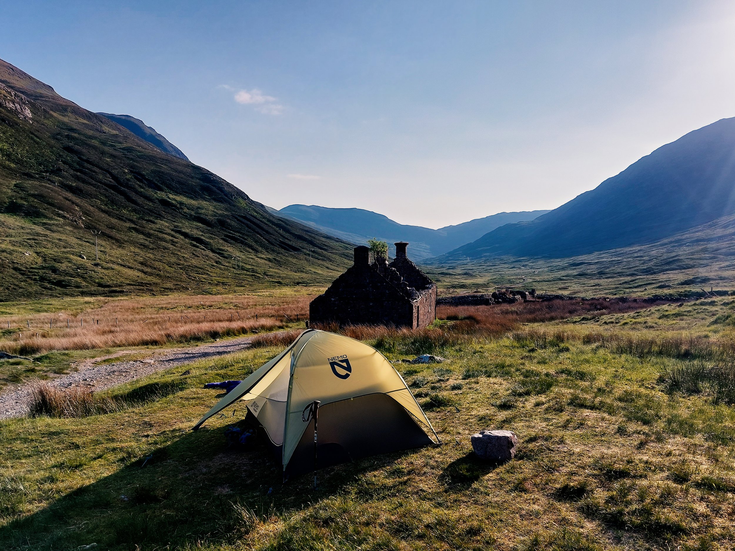
Wild camping by Tigh-na-sleubhaich

Loch Lomond (north)
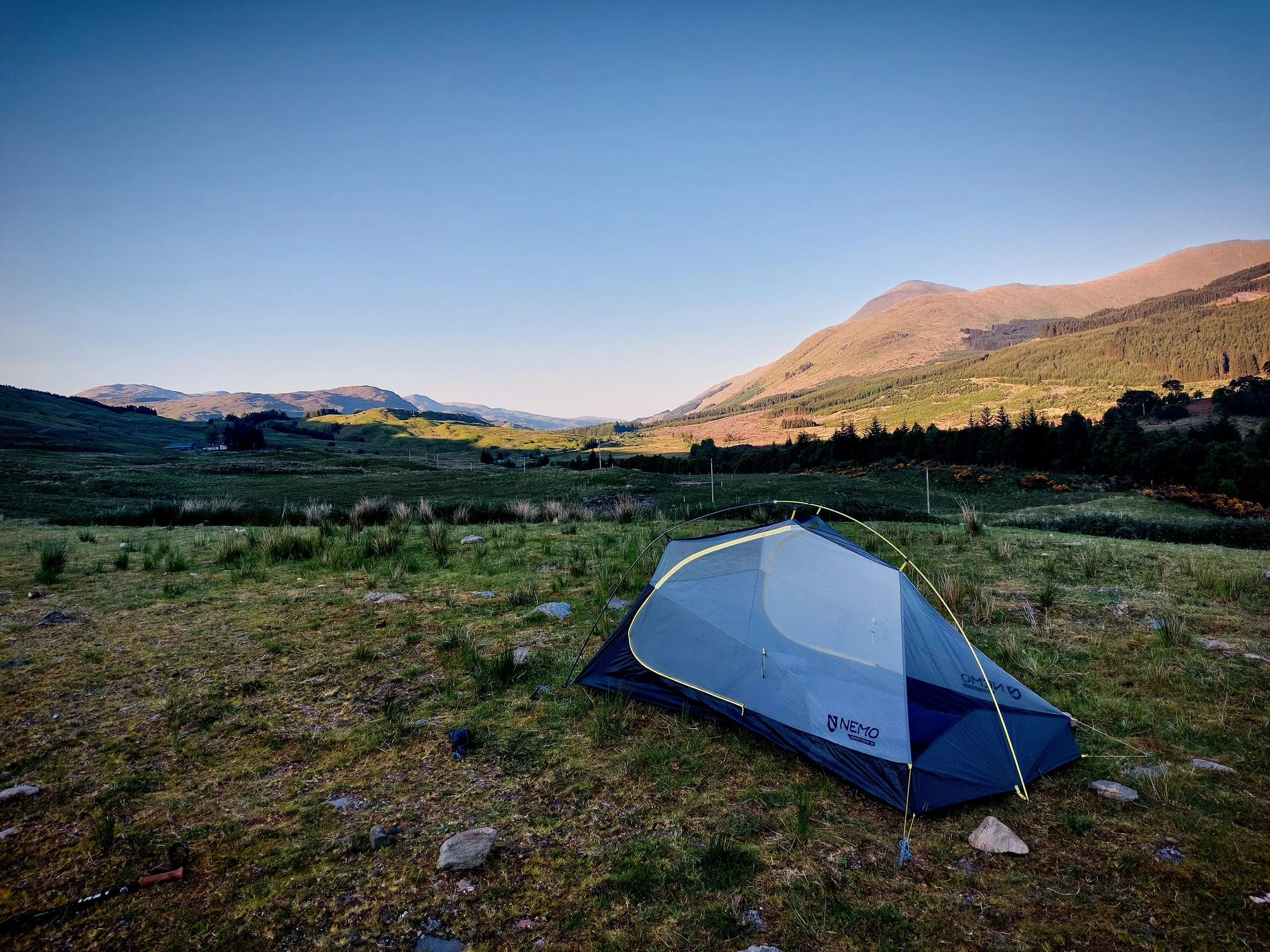
Wild camping by Crianlarich

Loch Lomond

Crianlarich

Loch Tulla

Kingshouse, Glen Coe

Old Military Road, Kinlochleven

Kinlochleven

Hiking to Fort William

Glen Coe
Loch Lomond

The Route
An overview
Frequently listed in the world’s top long distance trails, the West Highland Way will take you from the Scottish lowlands to the majestic Highlands. This iconic 155-kilometre route is a journey through Scotland's diverse landscapes, where verdant forests, shimmering lochs, and imposing mountains await around every bend. From the charming village of Milngavie to the historic town of Fort William, hikers are treated to breathtaking views and a profound sense of connection with nature. Whether you're seeking adventure, tranquility, or simply a challenge, the West Highland Way promises an unforgettable experience for all who tread its path.
I completed the hike in 6 days in May 2023. I was treated to weather unimaginable even to the locals! Not a single cloud in the sky for four days! Each new day brought new challenges as the terrain changed quickly from city outskirts to the lacustrine Loch Lomond and finally to the mountainous highlands. I thoroughly enjoyed my adventure and would like to share with you some of the key points to help you plan your trip.
How difficult is the hike?
The West Highland Way is neither a treck suitable for very beginers, nor is it a demanding hike for seasoned veterans only. The path follows many very well maintained footpaths and military roads, meaning that the paths are very well defined and you are often not far from help if needed. Having said that, the top half of Loch Lomond from Inversnaid hotel is by far the hardest part of the route. The path follows the loch through tight and tricky undulating paths. In addition, the weather may raise the stakes a few notches during the hike.
The hike is not suitable for total beginers, however it is a great hike for taking on your first long-distance or solo route if you’re a somewhat experienced hiker. The path passes frequently through small neighbourhoods of civilisation allowing you to resupply and rest up if needed. Yet, although there is some road-walking in the early stages, the relative proximity to civilisation in many parts does not make the hike feel easy or a ‘walk in the park’. Walking 150km is not small feat and should not be underestimated.

Highlights of the walk
These are my top three memories and locations from my journey along the West Highland Way:
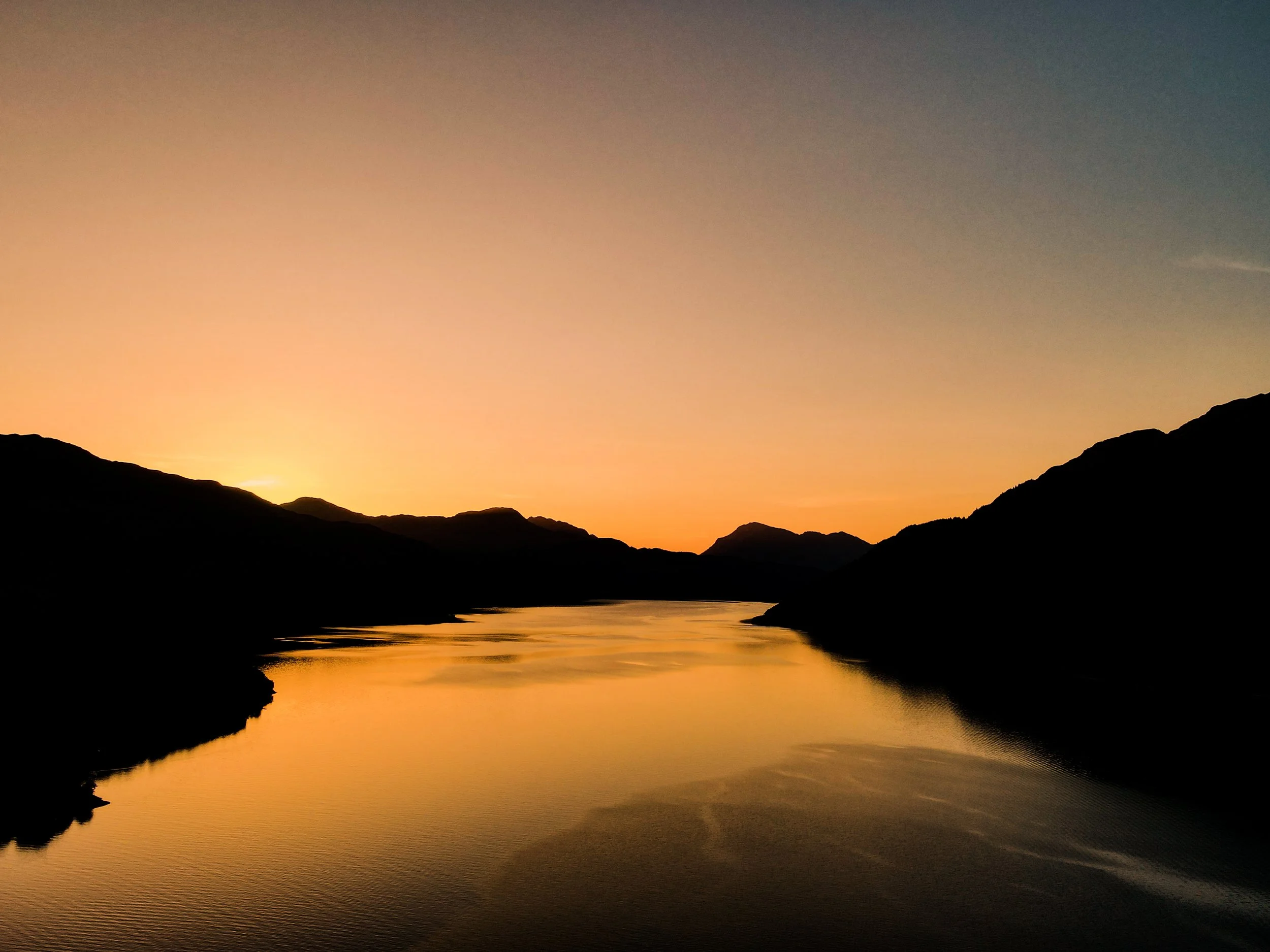
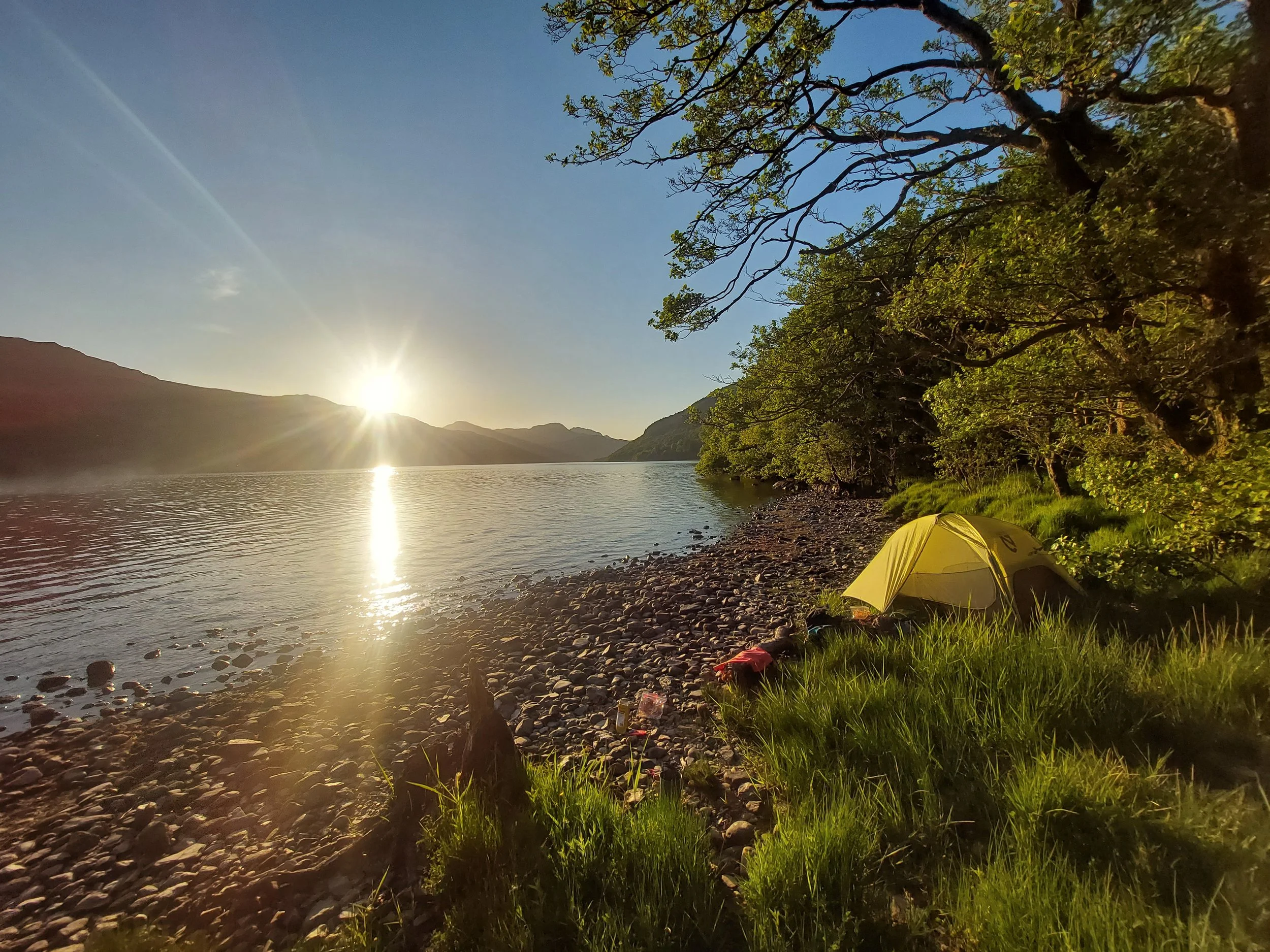
Wildcamping along Loch Lomond
Having aquired a camping permit for Loch Lomond (see Section: Accomodation for more), I pitched my tent along the shore of Loch Lomond just after Rowardennan. I was all alone to watch a spectacular sunset whilst enjoying my dinner. The weather was perfect. The stillness of the water was so calming and relaxing, what a great night!
The view inbetween Bridge of Orchy and Inveroran Hotel
I found this uphill much tougher than expected. Having stopped for a late lunch at Bridge of Orchy, all I could think about was reaching Inveroran Hotel to pitch my tent. Yet, the uphill in the 30 degree heat was relentless. It was all worth it however, as I was treated to stunning 360 degree views.
The last major uphill of the walk after Kinlochleven
Having completed the final major uphill of the walk, just after Kinlochleven, I was treated to an undulating old military road with views of the neighbouring Loch Leven. What a feeling knowing the hardest is behind you. I put on some good music, got my drone out, and enjoyed the view.


When to go (hint: midges)
There are a couple of things to keep in mind when deciding when to embark on the trail:
-
The wether is very unpredictable in Scotland. You must prepare for hot sunny days but also days of heavy rain and heavy wind. Any hiker in Scotland will know how quickly the weather changes, so you can not assume one nice day will carry on for much longer.
This all comes down to preparation. Bring good waterproofs but also sun cream, sterdy boots but also a cap.
Be careful on the path between Inversnaid Hotel and the top of Loch Lomond. I was very thankful it was dry then! The route along the Loch is the toughest section and must be taken carefully in the rain.
-
Midges are small, flying insects resembling mosquitoes, often found in swarms near water bodies. They are particular prevalent in the summer season from end of May to September. You MUST bring a midge net hat and also possibly midge repelant. Midges are most commonly around when the wind is low. Whilst the summer season gives you the nicest weather, there will also be more midges!
During my trip in end of May, midges were only a nuisance in the mornings and evenings as I was in campsite. During the walk, they were no problem at all. I only wore my midge net hat in the mornings and sometimes in the evenings.
-
You guessed it… Summer Holidays! Glasgow summer holidays run from end of June to the middle of August, so expect these times to be particularly busy.
-
First week of May: sections of the route between Bridge of Orchy and Fort William will be closed of for motorcycle trials.
April / May: diversions possible to accomodate for lambing. Not all areas are possible to be diverted, so take care and leave no trace. Find out more here.
Suggested itineraries
Below is a list of suggested itineraries from five to nine days. Below, you can also find a short description of the route between stages and a couple of useful tips for each stage.

Milngavie to Drymen
The begining of the walk is all about leaving the suburbs and entering the Scottish lowlands. I would say this is the easiest stage of the route, with walking along farms, roads and footpaths following roads. The stage is a good warmup for what’s to come, but until you rach Conic Hill, don’t expect breathtaking views along the way.
I stayed at Drymen camping. The campsite is a couple of kilometres before Drymen, so you will have to make this up on day 2, however the campsite offered all the basic facilities for £12. This included a spacious area to pitch my tent, as well as charging points, showers, hot water and clean toilet facilities.
Drymen to Rowardennan
Stage 2 takes you to quickly to Conic Hill. The hill offers amazing 360 degree views onto Loch Lomond and really inspires you to get stuck in for the next part of the walk. Beware on weekends, conic hill gets very busy due to its close proximity and easy access from Glasgow. The walk then drops to Balmaha, a good spot for lunch. I ordered some haggis at the Oak Tree Inn. The rest of the walk to Rowardennan largely follows the loch. On a warm day, you can swim in the loch, the water is very cold though! The walk is largely straight forward. There are typically many walkers on this route doing day hikes, going to the beaches etc.
I wildcamped just after Rowardennan (with a permit for the Loch Lomond area, see my section of accomodation for more). I was all alone to watch the sunset behind the loch, an incredible expereince!
Rowardennan to Crianlarich
Stage 3 takes you to the end of Loch Lomond and into the highlands, a real change of scenery. After 12km, you will reach Inversnaid hotel. This is a great place for a snack or to charge batteries. I had the best (without a doubt) lemon drizzle cake at the hotel. After the hotel is the most difficult stretch along the route. The route is tight, rocky and very undulating, particularly tough on the knees. Caution should be taken if attempting this part in heavy rain. Luckily, this section lasted only approximately 8km.
After leaving Loch Lomond, you will see the landscapes rapidly change into more hills and fewer signs of civilisation. The route to Crianlarich is well maintained, with a large portion on the Old Military Road. A great stop before Crianlarich is Beinglas campsite. There is a corner shop selling supplies and a nice restaurant to top yourself up.
Crianlarich itself is slightly of the main path. I wildcamped just before Crianlarich to save myself having to walk back up to the path in the morning.
Crianlarich to Inveroran
This stage was a very varied stage, passing through many many different landscapes. You will hike through a forest after Crianlarich before reaching Tyndrum. After Tyndrum, the landscaped becomes broader and broader. The section after Tyndrum is very exposed, so make sure to bring a cap / sun cream if the weather is very sunny and warm. 5km before Inveroran lies Bridge of Orchy. There is accomodation and food here as well as a railway station which can take you to Fort William or Glasgow. The picture to the right was taken in between Bridge of Orchy and Inveroran, overlooking Loch Tula. This was one the memorable views of the Way.
500m beyond Inveroran Hotel is where I pitched my tent, along with many others. The hotel allows this and offers campers food, water and toilet facilities.
5. Inveroran to Kinlochleven
Now in stage 5, you will truly feel in the highlands. The section can be split into two with Kingshouse in the middle. Up to Kingshouse, the path passes through a large plan surrounded by hills in the distance (photo to the left). Kingshouse is a great stop, offering good food, showers and camping (for those wishing to stop). After Kingshouse, the terrain becomes more mountainous with the famous Devil’s staircase. The staircase is is an approximately 250m climb. I met many people quite apprehensive about it, but after climbing to the top, everyone found it easier than expected. There is no rush and no competion, you can stop, take a rest if needed. Before you know it, you will be at the top and treated with great views overlooking Glen Coe.
The final descent into Kinlochleven is quite steep. Trekking poles may come in helpful for your knees. The paths are well maintained however and the descent is nothing more than a typical day hike.
6. Kinlochlevel to Fort William
The final step! After being treated to breathtaking views along the last week, this day may feel somewhat sad but also an excitement to reach the finish. The day starts with the final major uphill (approx. 250m) of the route to the reach the Old Military Road. The military road is long and straight, there is really one path to follow through the valley. I was met with sheep along the road as the pastures are used a lot by farmers. The final stretch of the way, after hiking down to the main road leading to Fort William is to be done as quickly as possible! Hiking next to the major road after a week of peace and stunning views is not exciting at all. After a couple of kilometres, you will reach Fort William where the official end is marked by a plaque and a statue comically referred to as the ‘sore feet statue’.


Weather
The United Kingdom occupies an position directly inbetween humid maritime air and arid continental air masses, leading to frequent temperature variations and atmospheric instability. So, expect a vast array of weather conditions over a couple of days. I was lucky and got 6 days of perfect sunshine, so it is possible, but always prepare for the rainy days as well.
My best advice is to prepare for all possibilities. Waterproofs (including boots) are essential as well as sun cream, and a cap to protect you from the sun. Winter conditions can be highly unpredictable and only go during the winter if you’re an experienced hiker
Weather forecasts
What to bring
This is a tricky one, it depends person to person! Listed below are some of the ‘essentials’ for the West Highland Way:
Midge net (and spray)
The MOST important of them all! If embarking on the walk
Footwear
Worn in, waterproof hiking shoes / trail runners are highly recommended to avoid blisters, pain in your legs and general uncomfort. Likewise, breathable shoes like slides or flip flops are great to at camp to allow your to feet rest and recover. I always bring blister plasters on long distance walks. These should ideally be applied prior to a blister, when you can feel one coming; then they will have most effect.
Toilet paper
There is no feeling worse than needing to use the toilet but not having toilet paper. Whilst its unlikely, it is reassuring to know its there! You don’t need to bring a full roll, that will take up unecessary space and weight. Bring about 1/3 to 1/2 a roll for week.
Everything else!
I haven’t named most items needed, you can find them in my packing list below.
Suggested packing list:

My midge net that I used at camp

Midge net!!
〰️
Cash!!
〰️
Worn boots!!
〰️
Midge net!! 〰️ Cash!! 〰️ Worn boots!! 〰️

Accomodation
Accomodation en-route is plentiful, check out my map in ‘The Route’ section above for the whole selection. There are a couple of things to bear in mind when planning ahead.
-
There are plenty of campsites along the way, with camping being a very popular option, check out my map above for the camspsites along the way. The campsites are reasonably priced and typically offer the basic amenities including hot water, showers, charging points and snacks.
A popular camping area is next to Kingshouse hotel. Campers may use shower and toilet facilities as well as the hotel’s restaurant and pub. There is internet signal and is a great place for a nights rest.
Wildcamping is allowed and is free! You can find many great spots along the way, free of the crowds. As with all wild camping, make sure not to leave a trace.
Camping management zone Loch Lomond: in order to combat large groups from leaving litter around the Loch, ANYONE camping in the management zone (see photo) must register in advance. Spots are few and go quickly, so do this as soon as registration opens. Find out more here.
-
There are many types of accomodation on offer along the route, see my map above for more details. Depending on your budget, you can opt in for youth hostels all the way up to five-star hotels (Kings house will set you back a little!).
Make sure to book well in advance as rooms are taken a couple months in advance often. In the larger towns like Milngavie, Glasgow or Fort WIlliam, this is less of an issue, you will be able to find accomodation on the day.

Food options
There are many restaurants and hotels / campsites offering food for all hikers along the route. See my map in ‘The Route’ for food options as well as the location of accomodation (which will all serve food). In addition, many campsites and hotels operate small shops selling snacks, gas canisters, drinks and other foods. I stopped for a top up at Beinglas campsite as well as the Co-op store in Kinlochleven.
Many accomodations offer to pack breakfast for you as you depart for the hike. In addition, the more major towns along the route (Milngavie, Crianlarich, Drymen and Kinlochleven) offer shops for resupply.
Local ‘must-tries’
Scotland is home of some great and unique food which I highly recommend you try.
Haggis: a savory Scottish delicacy crafted from finely minced sheep's heart, liver, and lungs, blended with oats, onions, and spices, delivering a rich, robust flavor. Perfectly paired with neeps and tatties, it's a culinary adventure that tantalizes the taste buds with tradition and authenticity.
I ordered Haggis at the Oak Tree Inn in Balmaha on my second day - it turned into a long lunch but well worth it!
Fish and Chips: a really divise one outside the British Isles, fish and chips are a timeless British classic featuring crispy battered fish, tender on the inside, and golden-fried chips, served piping hot for a satisfying crunch with every bite. A beloved comfort food that promises a deliciously indulgent experience, enjoyed by generations and cherished on every corner of the high street.
Whiskey: whilst not quite food! experience the essence of Scotland in every glass, with smooth, smoky flavors and hints of heather honey that capture the spirit of the Highlands. Savor the craftsmanship of local distillers, whose dedication to tradition ensures each sip is a journey through Scotland's rich heritage and rugged landscapes.
Phone and Internet
Wifi
Wifi is increasingly available in restaurants, cafes and accomodation. More and more places are offering the service each year. In the larger towns of Milngavie and Fort William, Wifi can be found easily. In addition, for the campers, Kings House can be a great place not only to refresh yourself with a shower they offer campers, but also to hook yourself onto the internet for free.
Mobile data
Check your phone provider for more information. By searching e.g ‘Vodafone Coverage Map’, you will be able to find out with regards to your provider. Typically, phone signal is good but likely you will not have a coverage entirely during the trail. Check your map for valleys coming up, they are the most likely areas for signal to be lost.
Charging
Scotland uses the UK standard 3-way plug. You will need an adapter if coming from overseas (Europe included!). Every restaurant / accomodation that I stopped in offered charging, it is readily available along the trail. Consider bringing a portable charger for multiple devices / if camping.

Maps and Waymarking
Maps
Maps come in two forms: digital or printed. Personally, I like the feel of a printed map as well as knowing its battery won’t die on you. Digital maps have advantages including often a GPS tracker, live weather forecasts and general ease of use and small size compared to a map. However, phones are dependent on battery life, sometimes internet signal and the performance of your phone can vary on a cold night or with heavy rain it may be difficult to use the touchscreen.
Maps require more planning. I like to draw the route out with a sharpie. Maps are often bulkier and the often cost between £10 - £20 each. However, self-navigating can be a rewarding and fun process on the trail. Don’t forget a compass too whe using a printed map.
Online Maps
Printed Maps (1:25,000 scale is recommended)
Ciceron guide book map (I used this map. It fits in your pocket and is very easy to read) - (click here)
Harvey maps - one signle 1:40,000 map (click here)
OS Maps - you’ll require a few - Explorer 342, 347, 348, 364, 377, 384 and 392 (click here)
Waymarking
The West Highland Way is incredibly well marked. The emblem is a white thistle within a hexagon on a post. For most of the trail, the path is clear and requires little waymarking but do always periodically check your map to make sure you haven’t strayed away from the course.
Cash or card?
Answer: CASH
Whilst the ability to use a card is becoming easier and easier (the large hotels will offer card payment), the use of card is still not guaranteed in many establishments along the route. Bring more cash than you expect. Having cash will be relieve stress if ever cought in a unexpected situation (needing a taxi, food, accomodation etc.). This has happened to me before, I can not overstress the importance of cash!
There are opportunities to withdraw cash in the followings areas:

Pack-carrying Services
A number of companies are now offering to carry your heavy backpack from one location to the next. This allows you to only carry a light day pack and make your hiking significantly easier. Prices for the full route are around £60 - £70. Booking transfers does however tie you into a fixed route and schedule.
Some of these companies are listed below:

Transportation
Transportation along the route is available but not frequent. There are multiple options along the way to skip sections or return to the start.
Glasgow to Milngavie (Train)
Most hikers will travel from Glasgow to Milngavie. This is very simple and cheap. Scotrail offer services every 30 minutes from Glasgow Queen Street / Glasgow Central. Note, on Sundays, the first outbound train departs Glasgow at 09:11.
Glasgow to Fort William (Train, Bus)
Scotrail run services between Glasgow and Fort William. The train journey is stunning with views unparalelled to most journeys in the UK, I would highly recommend (watch from 39:35 in my video!). The Journey runs for approximately 4 hours and stops at Crianlarich and Bridge of Orchy. This allows you the chance to sit back and see where you’ve hiked for the past week, a truly great and nostalgic experience.
Citylink run bus services between Glasgow Buchanan Street and Fort William, lasting approximately 3 hours. The bus passes through stops along the hike including Inveranan, Crianlarich, Tyndrum, Bridge of Orchy and Glen Coe.
Taxis
Several taxi companies operate along the route, some of which are listed below:
Drymen Taxi Service 01360 660 077
West Highland Taxis 01855 831495 (Fort William, Glen Coe, Kinlochleven)
Ambassador Taxis 0141 956 2956 (Milngavie)
24/7 Cars 01838 300 307 (Crianlarich)
Lochaber Taxis 01397 706 070 (Fort William)
Key contacts and Emergencies
Dial 999 or 112 for ALL emergency services including Ambulance, Police, Fire Service and Mountain Rescue.
The mountain rescue teams operating along the West Highland Way are:

Further references
There are some great ways to get further information regarding the hike! These three resources are where I find out most about any hike, not just the West Highland Way.
-
One of my most underrated souces of information, there is a facebook group for any hike out there. In the case of such a popular walk, there are many groups with thousands of members each.
Ask any question, read other questions, other posts, a faebook group is just a trasure trove of informtion. I can guarantee any question will get answered.
In addition, checking groups on the day of hiking can give important updates on the trail condition or anything ese to be aware of.
Click here to view a West Highland Way Facebook group.
-
To get a real sense of the feeling of a trail, there is no better site. YouTube offers a unique insight where words on a page simply are not enough. When watching a video, try and look out for things like busyness on trail, the path condition at the time of year and small details like sources of water, streams etc.
Most youtubers (below 10,000) subscribers will answer questions you may well have as well, I certainly do!
Finally, plug for my own video… I’ve tried to express my thoughts and feelings during the video as well as sharing some stunning scenary, so check it out!
-
My go to guides are always Cicerone.
See link here for more info.
For £10 - £20, the level of detail is second to none. Detailed descriptions of each stage, many key facts, a 1:25,000 map, the guide is well well worth it.
You will be able to learn abut the local area’s deep history as well as the geology of the area through this guide.


YouTube is a great source of information, not just my video! ; )